Introductory passage is provided by this website and may not represent the views of the archived document's author. BACK 
Search the Republic of Rumi |
Pakistan 1956: Geography The following geographic survey was written by Dr. W. B. Fisher Head of the Department of Geography, Durham Colleges, University of Durham, and appeared in The British Commonwealth 1956 published by Europa Publications Limited, London (1956). See the Synopsis of Subjects on the left for other items on Pakistan from The British Commonwealth 1956. Geography
West Pakistan consists mainly of the middle and lower valley of the Indus river, together with an adjacent mountainous zone on the west (Baluchistan). The northern frontier runs more or less along the first foothills of the Himalaya, except in the extreme north where it includes the main peaks of the Hindu Kush; and the eastern boundary of Pakistan may be said to be the Thar desert. Further north among the Himalaya lies the territory of Kashmir, which is a subject of dispute with India. East Pakistan comprises the eastern section of the Ganges delta and is thus almost entirely an alluvial lowland, with its eastern frontier at the beginning of the Assam hills. The actual boundaries of both East and West Pakistan were drawn mainly on a sectarian and religious basis, to separate Muslims and Hindus, and so largely ignore topographical features and economic units; thus the new boundaries have led to considerable difficulties, particularly as regards communications and the use of river water for irrigation. Climatically, the two regions of Pakistan are strikingly dissimilar. East Pakistan experiences the full effects of the summer monsoon (see India: Geography) with dramatic alternation of dry and wet seasons. Lying close to the Bay of Bengal, summer rainfall is intense, giving steamy oppressive conditions from June to October; while later in the year dry, moderately warm conditions prevail. Mean temperatures at Dacca range from 63° F. (January) to 87° F. (May), and annual rainfall is between 50 in. and 125 in., all but 10 in. falling between May and October (inclusive). West Pakistan receives only an attenuated and partly dried out monsoonal air current which has already deposited most of its moisture in the lower Ganges valley, hence rainfall is everywhere restricted. In addition to this summer monsoonal rainfall there are also very slight winter rains in some areas, produced by small depressions that work their way across Pakistan from as far west as Europe and the Mediterranean. Even however with this extra rainfall, most of West Pakistan is arid or sub-arid and depends, like Egypt and Mesopotamia, on irrigation from its rivers and canals. Maximum day temperatures can reach 125° to 135° during May and June, the hottest months; but frost is also common during the winter in the north and the hillier parts of the centre. Karachi, in the extreme south, has mean temperatures ranging between 68° and 88° with 8 inches of rain annually. Lahore has a temperature range of 61°- 96°, and 18 in. of rainfall. Pakistan with 76 million inhabitants (1951 census) is the sixth largest state in the world (in numbers) and the largest Muslim country-though only 85 per cent of its inhabitants are Muslims. Some 14 per cent of this total is regarded as literate. Lahore (pop. 1 1/2 million) is the largest city of Pakistan, and functions as a market and administrative centre for the Punjab. Karachi (1,126,000) is the capital and chief port, whilst Dacca (411,000) is the chief town of East Pakistan. Dr. W. B. Fisher Source: The British Commonwealth 1956 Back to Top

Search the Republic of Rumi
|
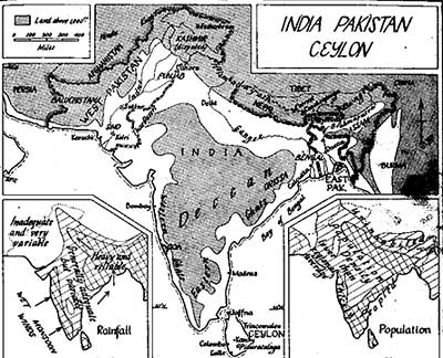 The
territory of Pakistan consists of two entirely separate units: West
Pakistan, bounded by Iran, Afghanistan and India, and covering 310,000
sq. miles; and East Pakistan (formerly East Bengal) which, except
for a coastline on the Bay of Bengal and a 200-mile frontier with
Burma on the east, is virtually an enclave within India. The two
units are over 1,000 miles apart, so that communication between
them involves either crossing Indian territory or traveling 2,500
miles by sea round the tip of India.
The
territory of Pakistan consists of two entirely separate units: West
Pakistan, bounded by Iran, Afghanistan and India, and covering 310,000
sq. miles; and East Pakistan (formerly East Bengal) which, except
for a coastline on the Bay of Bengal and a 200-mile frontier with
Burma on the east, is virtually an enclave within India. The two
units are over 1,000 miles apart, so that communication between
them involves either crossing Indian territory or traveling 2,500
miles by sea round the tip of India.| Page Hits | Visitors | BACK | HOME | CONTACT |